

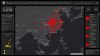
A team at the Johns Hopkins CSSE (US) has built a map that shows the spread of the coronavirus in near-real time.
Search results for "Google Maps Engine"

Collaboration yields fruitful decision support
Detailed soil and landscape data to help farmers make better decisions.
Best of the blogs
Spatial Source’s fortnightly round-up of the best in cartography, spatial analysis and creative applications of GIS.

Best of the blogs
Spatial Source’s fortnightly round-up of the best in cartography, spatial analysis and creative applications of GIS.

Q&A with Ralf Duering
In an exclusive excerpt from Position 96, we chat with Airbus’ SAR guru, Ralf Duering.

Lessons learned from the relaunch of Queensland Globe
Queensland Globe now includes 652 data layers from almost every government department.

The risk of drone collision accelerates
The federal government predicts a doubling in the number of RPAS in 2017, and a fast growing risk.

Sea level rise mapping reaches Vanuatu
Australian spatial expertise releases Coastal Risk Vanuatu, the Pacific Islands’ first flood prediction tool.

32 years of satellite data show Australia drying up
Remote sensing of surface water over 32 years reveals changes in Earth’s water systems.

Best of the Blogs – 1 November 2016
Time and place for data; Female navigators; Hunting Loch Ness in 3D – best of the blogs time!


