

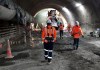
City Rail Link and LINZ are collaborating on Auckland’s new 3.45km twin-tunnel underground rail link.
Search results for "LINZ"
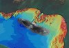
Uncharted NZ shipwrecks mapped for first time
The wrecks of two ships that sank in 1912 and 1940 have been captured through a hydrographic survey.
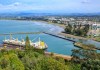
Gisborne hydrographic seabed survey underway
Coverage will extend up to 4 nautical miles from the coast and up to 80 metres deep in some places.

NZ elevation project more than 50% complete
The release of 3D mapping data for Waikato and Southland means more than half of New Zealand is covered.

Q&A: Martine Woolf, Geoscience Australia
Woolf leads a team of experts who are implementing Australia’s next-gen positioning projects.

SouthPAN service outage following Inmarsat failure
The outage is affecting farmers and other users who have come to rely upon SouthPAN’s higher accuracy.

South Island SouthPAN uplink station takes shape
Installation has begun on a SouthPAN uplink site at the SpaceOps NZ Satellite Ground Station near Invercargill.

Flood imagery supports NZ cyclone recovery
A birds-eye view of Cyclone Gabrielle’s impact on NZ’s North Island east coast is now available online.
Here’s what’s in our latest issue!
The Feb/Mar 2023 issue of Position magazine is out now, packed full of all the latest geospatial news.

LiDAR survey of New Zealand’s Taranaki region
A ground-breaking aerial LiDAR survey has produced a wealth of valuable land-surface and elevation data.


