


A recent update to this historic portrait shows Earth as a tiny speck in the vastness of space.
Search results for "NASA"
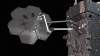
NASA to trial in-space manufacturing
NASA has contracted Maxar to robotically manufacture an antenna and spacecraft beam in orbit.
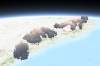
NASA releases 3D view of Australia’s bushfire smoke
The Bureau of Meteorology is using the map to improve air quality forecasts.

NASA survey of Antarctic ice launches from Hobart
NASA’s Operation Icebridge will be the largest survey of Earth’s changing sea ice ever taken.

UNSW harnesses Google and NASA data for ecosystem mapping app
REMAP enables simple and swift analysis of Landsat data for ecosystem monitoring.

NASA’s push to drive commercial data use
Release of remote sensing toolkit aimed at driving commercial uptake of NASA-produced Earth Observation data.

GEDI, NASA’s massive LiDAR instrument, to map the world’s forests in 3D
Yes, it’s pronounced “Jedi”.

TESS, NASA’s Kepler successor, to seek extrasolar worlds
NASA’s newest planet hunter will map 85 percent of the sky.

The eclipse NASA is going to blitz with science
NASA is sparing no expense in order to get the most comprehensive eclipse dataset yet.

NASA to share spatial expertise at Locate and Digital Earth
Special sessions at April’s Locate17 and Digital Earth Symposium include the likes of NASA, CRCSI and UoM.


