


Strategic plan mandates DE and BIM across entire infrastructure asset lifecycle.
Search results for "asset management"

Leica releases mobile asset monitoring solution
Leica has released Jasset, a monitoring solution that locates mobile and semi mobile assets.

Bentley AssetWise APM v7.2 announced
v7.2 allows infrastructure assets to be viewed in the context of engineering information.
ANZ Disaster and Emergency Management Conference call for abstracts
The Australian & New Zealand Disaster and Emergency Management Conference will provide a forum to examine the issues surrounding natural and man-made hazards. The program will focus on Prevention, Preparedness, Response & Recovery, and will include keynote addresses, concurrent sessions, and workshops covering human and social issues, economic and environmental challenges, infrastructure, community and communication […]

1Spatial launches big spatial data management tool
Geospatial company 1Spatial has released an enhanced 1Spatial Management Suite, which includes Workflow, Plan, Maintain, Publish and 1Spatial Cloud. The software is aimed at public and private companies that handle high volumes of business-critical spatial data, on-premise or in the cloud. Marcus Hanke, chief executive at 1Spatial explains: “The rise and impact of big […]

NSW to view education assets spatially
The New South Wales Department of Education and Training has a new mapping interface for its Asset Management System (AMS). Developed by supplier Omnilink, the system allows users to visualise their asset data across 3,000 sites geographically. Users at the department traditionally viewed asset data on Oracle forms. Omnilink blended Oracle forms with […]

Leica and Geolantis partner for cloud based utility mapping
The Leica DX Manager simplifies utility surveying and asset management workflows.

Real-time incident capture and reporting
Cloud-based solution for crowd-sourced asset management and more.
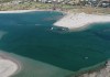
Hydrographic survey reveals river mouth narrowing
The mouth of the Murchison River is being dredged after the channel width was shown to have more than halved.
Carbonix flight milestone for SA Power Networks
The Australian-made Volanti UAV conducted a BVLOS inspection of 150 km of powerlines.


